Archive

Author Archive

How to Portage a Canoe Solo at Boundary Waters in 26 Easy Steps (Day 54)

September 11th, 2009 2 comments

Before going on the Boundary Waters Canoe Area trip, I figured the hard part of portaging the canoe would be having to carry the canoe around. Not that carrying the canoe is fantastic or anything, just that — it’s more the inconvenience of having to unpack and re-pack every time than it is the canoe hauling. IMHO.

Here are photos to help you sympathize (empathize? I’ll take what I can get).

bwca_portage-landingStep 1: Land ahoy! Identify the landing up ahead (in this case, it’s where those rocks are on the right-hand shore).

bwca_land-the-canoeStep 2: Beach the canoe by paddling sort of hard and aiming the bow for a soft, rampy spot (if available).

bwca_climb-outStep 3: Carefully — *carefully* — climb up to the bow of the canoe and get out, making sure to maintain a low COG and balance all the way — this is expecially (you heard me) true if the landing is more rocks than sand.

bwca_haul-canoe-onto-landStep 4: Pick up the canoe at the bow and haul it the rest of the way onto land.

bwca_remove-bear-cannisterStep 5: Remove the bear barrel from the canoe and put it on the ground somewhere.

bwca_remove-backpackStep 6: Take your backpack out of the canoe.

bwca_attach-yokeStep 7: Attach the yoke to the canoe by lining up the clamps and tightening them down. Then, tighten them further.

bwca_empty-canoeStep 8: Take the plastic cover off your backpack, remove paddles, fishing poles, and anything else still lying around in the canoe, then take a picture of it all.

bwca_stow-pack-coverStep 9: Stow the backpack cover into one of the side pockets on your pack.

bwca_backpack-onStep 10: Put your backpack on. Almost ready to go, sport!

bwca_lift-canoeStep 11: Lift canoe over head. But don’t do it like I’m doing it in the photo — grab it around the middle and work it out that way. Trust me.

bwca_canoe-on-headStep 12: Put yoke around neck with pads on shoulders.

bwca_transport-canoeStep 13: Start walkin’!

bwca_arrive-at-put-inStep 14: Arrive at put-in location (the end of the portage).

bwca_put-canoe-downStep 15: Remove canoe from head. This will, 60-percent of the time, result in having your hat fall down over your face.

bwca_remove-packStep 16: Take off your pack and PFD.

bwca_cover-packStep 17: Put the plastic cover back over your backpack.

bwca_hike-back-mapStep 18: Head back to where you left the bear barrell and paddles. Maybe check out your map along the way.

bwca_put-on-barrelStep 19: Once you’ve arrived at the take-out, strap the bear barrell onto your back.

bwca_pick-up-paddlesStep 20: Pick up your paddles and fishing pole and whatever else.

bwca_carry-paddlesStep 21: Carry them back down the path toward the put-in location.

bwca_re-pack-canoeStep 22: Throw everything back into the canoe.

bwca_put-on-pfdStep 23: Put your PFD back on.

bwca_put-canoe-in-waterStep 24: Push, pull, and drag the loaded canoe back into the water.

bwca_get-into-canoeStep 25: Carefully get back into the canoe. This is trickier than getting out, especially on rocks (as shown).

bwca_shove-offStep 26: Sit down and shove off, matey! There are bigger adventures — and longer portages! — yet to come.

Anyway, point being: carrying the canoe isn’t that big a deal when it comes to portages. And it takes about 4x longer to do a portage if you’re trying to photograph yourself doing it. And to a certain extent, the portages break up the sometimes-monotony of paddling. And the trip I did didn’t have all that many portages (five each way, the longest of which was a half-mile). But every portage I did required me to hike the route three times (there, back, there), whereas people not doing it solo would probably only hike each one once.

C’est. La. Vie.

More to come on the actual, like, trip part of the trip. You’ll see.

bkd

Up Into the Northwoods (Day 53)

September 11th, 2009 3 comments

Understanding that it is the suspected home of Coal Dunkirk, I stayed the night of Day 52 in Bemidji, Minn. I liked how everyone there (as well as everyone north of there) talked like Frances McDormand from Fargo (ah heck, like a lot of characters from Fargo).

The drive from there to Ely, where the canoe trip would kick off, was pleasant enough and mostly looked like this:

road_to_elyAnd every little town has an identical, small, white Lutheran church in it.

mn_lutheran-churchLike this one.

Made it to Ely in mid-afternoon. Nice enough town, totally tourist-dependent, and a little scared-looking. I don’t know what I mean by that, but I’m pretty sure it’s true. Looked like every business was on the brink of bankruptcy, I guess. Maybe that’s what I mean by it.

ely_main-streetSee? Scared.

Got there, registered with the outfitter, who put the canoe on top of my truck, then took a tour through the bait shop. It turns out you don’t really fish for trout in Northern Minnesota, you only fish for pre-historic things that are better left unseen by the light of day. And it turns out that things that look like that sometimes bite on leeches. That morning, I’d never seen a leech before in my life. By evening, I owned a big ol’ sack full of ’em!

leech_bagLook at ’em go!

Stayed that night at the outfitter’s bunkhouse (btw, I used Voyageurs North as my outfitter and they were very cool, mad props), where I met some people from Wisconsin. The Wisconsinites also talked sort of like Frances McDormand from Fargo. Their leader was impressed (or appalled?) that I was going out to Boundary Waters by myself and gave me some firecrackers to throw at bears when the time came.

And then I slept badly.

bkd

Welcome to Minnesota — State #11

September 7th, 2009 1 comment

It’s an oddly shaped state.

welcome_minnesotaThe bug splatters are multiplying.

I entered Minnesota at Fargo-Moorhead. Gas is pretty cheap in MN (I bought it for $2.37 in Bemidji this morning). Confusingly, gas here generally comes in two octanes, both at the same price. I’m wondering if the cornpower folks have something to do with that.

And I’m heading to Boundary Waters tomorrow. In at #16 (Nina Moose River), paddling up to Lake Agnes, and camping there for a couple nights. Just, you know, fyi.

bkd

Categories: northern states Tags: ,

Theodore Roosevelt National Park and the Very Badlands (Day 52)

September 7th, 2009 2 comments

Theodore Roosevelt National Park is exactly the same as Canyonlands in Utah if you take Canyonlands and then:

  • Smash it down a bit.
  • Remove any arches or bridges.
  • Sepia-tone it.
  • Add infinite bison.

There are also prairie dogs, at least one dead porcupine, and wild horses at TRNP.

tr_cloud-vHey look! They have clouds in North Dakota, too!

tr_clouds-in-riverAnd sometimes those clouds get reflected in the Missouri River.

tr_missouri-riverOther times, the Missouri River is somewhat less reflective.

tr_badland-overviewBadlands, with neither river nor clouds.

tr_lone-treeLittle tree on the prairie. By itself. Next to a double-track pathway.

tr_wild-mustangsMy trip through the wild mustang drive-thru.

I camped there for a night — there are a lot of trains that pass nearby, but it only cost $10, so that mitigates.

Should probably say something profound, but I’m very sleepy and am getting up in 6.5 hours, so maybe you can make something up for yourself. (Thx.)

bkd

North Dakota: Welcome to the West Region (State #10!)

September 7th, 2009 Comments off

20% of the way there (in terms of states visited, yes)!

north-dakota_welcomeThe portrait on the sign is Theodore Roosevelt.

Although, let it be said that Highway 85 from Hill City to the 94 is one boring stretch of highway. A boring stretch of highway that Rand-McNally considers “scenic”, yes. I question the wisdom of Rand-McNally.

bkd

Categories: northern states Tags: ,

Deadwood, Live Tourists (Day 51, Part 2)

September 7th, 2009 Comments off

I’m guessing Deadwood’s peak is when the bikers flock back to Sturgis. I’m a little disturbed by the number of bikers there are on our modern highways. Actually, I’m mostly just disturbed by the fact that 75% of them are retirees and don’t seem willing to travel at speeds approaching, you know, the speed limit. Meh.

Deadwood: the only town left in America that still thinks Kevin Costner is pretty cool. But good for him — he probably needs it. They’ve revitalized the town’s 19th-century mainstreet through gambling — which is probably appropriate for a town that was sort of built on gambling to begin with. Plus Wild Bill Hickok died here.

deadwood_hickok-death-chair

In this chair right here, in fact. Look!: you can still see where he ripped the original vinyl!

deadwood_main-streetMain Street, restored.

Most of the people wandering around here were senior citizens. Sort of like Vegas: eyes glazed over, absent-mindedly pushing buttons on slot machines, discussing the qualities of a diverse set of buffets. Oh well. It sort of looked like an old wild-west town anyway.

bkd

Legion Lake Campground at Custer State Park

September 7th, 2009 Comments off

Stayed at this campground for a couple nights. It’s noteworthy because only five of the 15 sites have trees anywhere near them, otherwise you’re just camping on grass next to your neighbor who is also camping on grass. Also noteworthy for being overrun with bison.

legion-lake_campgroundThis bison guards the bathroom. And the photo reminds me of the Simpsons episode where Mr. Burns buys the Count Chocula cereal because the picture on the box looks like him.

legion-lake_campground-bisonFortunately, I got a site next to a tree, which offered some protection from the raging herd.

The campsite cost $20/night, but on the plus side the bathrooms have showers in them — you just have to fight through the bison before you can use them (and believe me, once you’ve wrestled a few bison, you *need* a shower).

bkd

Norbeck Byway and the Needles Highway (Day 51)

September 7th, 2009 Comments off

My favorite part of South Dakota was driving these two roads. You see the best parts of the Black Hills (even views of Mt. Rushmore!), get to drive through dynamited tunnels, and it’s got interesting bridges: unexpectedly cool. The road goes from about Mt. Rushmore (actually Keystone, a town) into Custer State Park, then heads up north back out of the park to — well, to the park boundary.

norbeck-byway_pigtailFor some reason these are called pigtail turns. You go over the bridge, do about 270 degrees, then go back under the bridge. And if I’d thought about it a little more, I would’ve stopped and taken some better pictures.

norbeck-byway_rock-tunnelAnd there are all these cool one-lane tunnels. Not pictured: the tunnel itself frames a view of Mt. Rushmore (but there was traffic behind me, and…).

norbeck-byway_wild-donkeyUn burro salvaje!

needles-highway_needle-tunnelEvery biker’s true passion: taking photos with a buddy. This was the narrowest tunnel on the Needles Highway — about eight feet wide.

needles-highway_needleThis formation is known as “the needle”. It’s probably better without the shadow, but I wasn’t waiting four-to-eight hours just to find out.

Anyway, point being: cool drive. I think the Black Hills could adequately be covered in a day, though: cave, Crazy Horse, Rushmore, Norbeck/Needles, and you’re out of there, heading toward… huh. There’s not much else around there. Tja.

Also: the rock formations that are the Black Hills’ signature (apparently) reminded me some of the Sächsische Schweiz south of Dresden, except that the “Schweiz” has a big ol’ river, castles, old bridges, and very quaint towns in it. Maybe South Dakota could look into adding some of those. (The similarity of the rock formations is sort of uncanny, though.)

bkd

Harney Peak Loop Hike (Day 50)

September 6th, 2009 5 comments

The peak was cool. Tallest peak between the Rockies and the Pyrenees, they say (7,244 feet!). The loop hike itself was not as cool. Hint: if you’re going to hike to Harney Peak, take the shortest route possible. Don’t think you’re going to get extra credit for taking the long route. You just get more horse manure to walk through (or around — you can walk around it).

Not really any photos of the hike on the way up, since there wasn’t anything to take photos of. I mean, trees, horse scats, but — yeah. Not big trees, just trees. Five to seven miles of trees each way.

Peak:

harney-peak_watchtowerThere’s a fire tower at the peak.

harney-peak_watchtower-panoramaNo fires!

harney-peak_looking-southNo fires this direction, either.

harney-peak_creek-crossingThis is what it looks like when you try and photograph yourself crossing a stream.

  • The hike is probably worth it if you go the shorter route.
  • The shorter route would have you starting at Sylvan Lake. You can make a loop out of it by going back by way of Little Devil’s Tower.
  • Any book that says that the loop starting from Iron Creek Horse Camp and returning via the Grizzly Bear Trail results in a hike of 10.5 miles is off by 2-4 miles. No joke.
  • As much as I love horses (now), it doesn’t seem right that 3% of trail users get to befoul the trail for the other 97%.
  • The trail on the way back down was marginally more interesting because of all the calcite flakes that were in the dirt — it was like someone had spread glitter on the entire return leg of the trail.
  • Calcite flakes don’t photograph well.

I dunno. I don’t like hiking for the sake of hiking. Frex: no worthwhile hike should deliver you to a parking lot two miles into the hike. Plus, aside from the peak, seems like you get better views of better rocks by driving the Black Hills than by hiking them. You know, from what I saw.

Hmm.

bkd

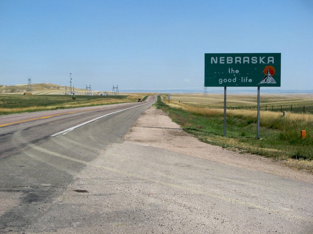
Nebraska… the Good Life (So Long As You Like Corn) — State #9!

September 5th, 2009 3 comments

Drove 70 miles out of my way so I could say I’d driven to Nebraska. Here’s proof!

nebraska_welcomeThose might be hay fields actually.

To celebrate the occasion, I went to the Wal-Mart in Chadron where I bought wiper fluid. Seemed appropriate.

bkd

Categories: northern states Tags: ,
телефонный справочник минска on-line волгоградский справочник найти телефон по адресу г орёл как найти по адресу номер телефона в г брянск телефонная база мариуполь найти по адресу и по фамилии номер сотового телефона поиск людей по адресу краснодар бесплатный телефонный справочник beeline здесь получить адрес через номер телефона как узнать по ip-адресу местоположение узнать тут телефонная база данных квартир местоположение мобильного телефона билайн сальск справочник телефонов тут перехватчик звонков и смс телефонная справочник телефонов могилева онлайн как узнать справочник телефонов г бердск помогите найти человека по номеру телефона мтс тут поиск фирм по номеру телефона москва справочник телефонов челябинской области троицк телефонная база с мобильными калининград найти утерянный телефон справочник телефонов верхней пышмы г братск справочник телефонов телефонная поиск людей по фамилии и номеру телефона найти местонахождение человека на номеру телефона поиск человека по городу и фамилии адресно телефонная база данных новосибирска ссылка тут телефонный справочник адрес по телефону г вологда ссылка поиск места телефона по номеру как найти человека по его имени и фамилии смс шпион смс перехватчик читаем чужие смс сообщения здесь адрес абонента по фамилии найти местонахождение человека на номеру телефона sitemap